
Video
Map
Springwater Corridor Trail East Segment
Multiple Jurisdictions
Click map images for larger maps
Location and Arrival
 The Linneman Station Trailhead provides facilities in a reconstructed train depot including a water fountain and picnic tables")
1) The Linneman Station Trailhead provides facilities in a reconstructed train depot including a water fountain and picnic tables

The Linneman location provides two accessible parking spaces next to the converted train depot and picnic area
 Gresham Main City Park location provides ample newly-built parking serving both Springwater and Main City Park")
2) Gresham Main City Park location provides ample newly-built parking serving both Springwater and Main City Park

Gresham proudly announces its Main City Park to Springwater users – the lovely neighborhood park is worth a side visit
![Gresham is well served by MAX and TriMet bus, as indicated by the Gresham Transit Center
[photo by Steve Morgan]](images/location/4A5C737638BE42C58F52147B2045DA62/Springwater Location 5.jpg "Gresham is well served by MAX and TriMet bus, as indicated by the Gresham Transit Center
[photo by Steve Morgan]")
Gresham is well served by MAX and TriMet bus, as indicated by the Gresham Transit Center
[photo by Steve Morgan]
[photo by Steve Morgan]
 The Springwater Trail-head parking area at Hogan Road provides the most central location and ample and easy parking")
3) The Springwater Trail-head parking area at Hogan Road provides the most central location and ample and easy parking

From the parking lot there is a narrow, older ramp that takes one down to the level of the Springwater Corridor Trail

This is the bottom of that ramp if one was trying to get back to the parking lot
 Boring Station Trailhead Park provides accessible parking, restrooms, water fountain, picnic facilities and a playground")
4) Boring Station Trailhead Park provides accessible parking, restrooms, water fountain, picnic facilities and a playground
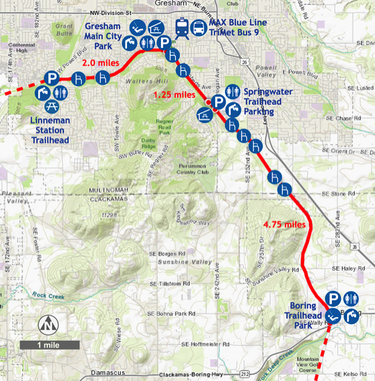
The slightly outdated map, inset above, shows the entire Springwater Corridor Trail, which now extends from the Steel Bridge to Boring. Since the map was first published, the 2.5 mile section from Rugg Road to Boring was completed, in late 2017.
Although the “Sellwood gap” remains unfinished, more sections have been completed since the map was made; but, as for the Cazadero Trail continuation — forget it, for now. They need someone to donate a railroad trestle, or two, to span the Deep Creek ravine. Any takers?