
Video
Map
4T Trail Loop
SWTrails and various jurisdictions
Click map image for larger map
4T entire loop overview


4T Trail overview
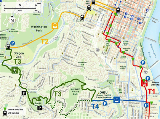
Starting at the base of the Tram [or at Tilikum Crossing, for more options], the Portland Streetcar takes one through many of Portland’s finest neighborhoods, and past most of its landmarks and diverse dining. Next, the MAX connects to Providence Park, home of the Timbers and Thorns, and through a long tunnel to the Oregon Zoo and Washington Park with its many amenities, including Hoyt Arboretum. A taxing hiking trail takes one up to Council Crest, highest point in the city with views to prove it; another taxing hike gets one down, and then up again, to the Portland Aerial Tram for an awe-inspiring ride back to the Streetcar below, about four hours later. Phew!
Trail segments—numbering sequence is from AR
T1 From the base of the Tram via Streetcar to the MAX at SW Morrison Street
T2 From the MAX at SW Morrison Street to the Oregon Zoo MAX station
T3 From the Oregon Zoo MAX station up to Council Crest
T3 From Council Crest down and then up again to OHSU and the Tram station
T4 From OHSU and the Tram station back to the starting point
On-street by-pass in case of muddy trails
